I will begin by sharing a view from the northern tip of the island, which I must confess, I find decidedly less enchanting than the southern. However, this morning I found myself contemplating potentially magical activities that might be conducted on this northern tip--upon which I will elaborate a little
 later.
I'm afraid that this morning, while not terribly frigid, was nonetheless quite overcast and glazed with a patina of institutional gray. On a bright sunny day, this vista would surely appear far more attractive, and I will undoubtedly share such a perspective in some future blog entry. But for today, we will have to content ourselves with this bleak but formidable view of 'Ol Muddy barreling her way down from the north. While snapping this picture, I was standing at the edge of a cliff with a decidedly sheer drop, although you could carefully make your way down if you were sharply inclined (yuk yuk).
From here, I continued along West Island Avenue, and by the time I reached the railroad bridge (where yesterday, as you may recall, I was stopped short by a passing train), I had decided that today would be 'Bridge Day.' That is, today I will be sharing a view of each of the bridges which provide the island with a means of ingress or egress.

Here, then, is the first bridge I come to after setting out each morning on my daily constitutional, what I refer to as the 'railroad bridge.' I snapped this picture after I had crossed over the tracks, or in other words, from the southern side of the tracks. I have crossed this bridge on foot, just as I have crossed every bridge that is connected to the island, although this is not a bridge that just anyone would cross on foot. To be honest, I'm not sure if it is strictly legal to do so, but why dwell on such minor technicalities? I prefer to dwell instead on the bridge itself while crossing it, as it offers a unique perspective on the river, the city, and the island, while also imparting that strange feeling of being neither here nor there, of being in the middle of things--in medias res, as the ancient Romans would have it.
Continuing south, after passing the Grove Street Flats and DeLaSalle High School, I came to the Hennepin Avenue bridge, named for Father Louis Hennepin, a Catholic priest, missionary, and explorer of the interior of North America, in honor of the fact that Hennepin was reportedly the first European to discover the Saint Anthony Falls a short distance downriver.
 Here is the Father Louis Hennepin Bridge as seen when approaching it from the north, and standing roughly in front of the western side of DeLaSalle High School. Again, a bleak and sunless day, but it's what I had to work with today and I'm not much of a photographer on the sunniest of days.
As I snapped this picture, the Grain Belt Beer sign was almost directly to my left. The back of that sign is not terribly attractive, as you may recall from a previous post, but the front is pretty eye-catching, and will certainly be included in some future post. As I passed underneath the bridge, I was struck by a perspective that I felt would make a more attractive picture, so I pulled
 out the camera and snapped this one. For this picture, I am underneath the bridge and looking straight across the river toward downtown Minneapolis. On the left side of the bridge are the lanes that carry eastbound traffic to Northeast Minneapolis and beyond. The right side lanes bring motorists (or pedestrians) to downtown Minneapolis and beyond. When we reach the other side of the island, you will see that the two sides of the bridge diverge more widely, so that the bridge really appears as two distinct bridges--which, as this picture shows, it actually is, yet we tend to see it and think of it as a single bridge.
From here, I continued to the southern tip of the island, where I was pleased to discover that my silver Christmas ball remains hanging on its limb--how much longer will it remain, I wonder? A short distance north of the south tip--on the eastern side of the island now--we come to the small wooden bridge known as the Merriam Street Bridge, which leads to St. Anthony Main Street, and the charming area known as the St. Anthony Main area. Here is a link to more information about this bridge: http://en.wikipedia.org/wiki/Merriam_Street_Bridge
 The St. Anthony Main area, which you enter after crossing this bridge from the island and making a hard right, boasts a number of quality restaurants, cafes, a movie theater, and a place where a tourist (or non-tourist) can sign up to tour the area on a Segway--a motorized scooter-type gadget that gained a lot of exposure in the movie 'Mall Cop' starring Paul Blart. I will address the Segway phenomenon more expansively in a future entry. I worked on St. Anthony Main for two years and have a special fondness for it: I've spent much time there, and have seen the area evolve in a variety of ways over the years.
On the Nicollet Island side of this bridge, as soon as you come off the bridge, stands the Nicollet Island Inn, a charming little bed and breakfast with a bar/restaurant. Continuing on my way this morning, I walked passed the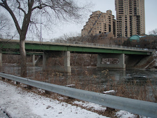 Inn and stopped to snap a picture of, first, the section of the Hennepin Bridge carrying eastbound traffic, and a little farther on, the section carrying westbound traffic. As you can see, the Hennepin Bridge spreads its legs rather widely on the eastern side, and in fact there is a short block between them.
In the first picture (at left), the side with eastbound traffic is in the foreground, but you can see its companion behind it, a bit further north. The second picture (below, left) shows the section with the westbound traffic only, yet you also see, in the distance, the next bridge on our tour, and the second to last means of egress from the island before I return to my starting point and home.
 Inn and stopped to snap a picture of, first, the section of the Hennepin Bridge carrying eastbound traffic, and a little farther on, the section carrying westbound traffic. As you can see, the Hennepin Bridge spreads its legs rather widely on the eastern side, and in fact there is a short block between them.
In the first picture (at left), the side with eastbound traffic is in the foreground, but you can see its companion behind it, a bit further north. The second picture (below, left) shows the section with the westbound traffic only, yet you also see, in the distance, the next bridge on our tour, and the second to last means of egress from the island before I return to my starting point and home.
 Before we reach the next bridge, though, it's worth pointing out (I think) that thus far my morning walk has established that I have seven distinct ways off the island--eight, if you count the downtown Minneapolis side of the Hennepin Bridge as two distinct bridges, which it is--nine, if you count swimming, which I would politely decline at this time of year (and maybe at any time of year)--and ten, if you also include the use of a canoe, kayak, dinghy, or other watercraft. But now lets continue, past DeLaSalle High School's eastern side, to the next bridge, which leads to Northeast Minneapolis. Can you infer which bridge this is?
 That's right, it's the other side of the railroad bridge--the first bridge encountered on this morning's excursion, when we were on the west side of the island. Here it is now, on the east side (East Island Avenue), where it brings trains to and from the east side of the Mississippi. I have a special fondness for this bridge, as it provides me with the quickest and most direct route to the section of Northeast Minneapolis containing the nearest grocery store, liquor store, and a large variety of shops, bars, and restaurant. Once again, however, it is a bridge that not everybody will cross, and one that I am not sure I cross with the complete approbation of Minneapolis's Finest.
Nevertheless, the bridge is equipped with a sturdy steel catwalk along its southern edge, which I find perfectly suitable to my crossing needs. Admittedly, there is not a fence or an especially protective guardrail running along this catwalk, and it is conceivable that a careless or drunk person could slip under the cable and plunk into the river, especially in winter when the catwalk is encrusted in ice, but I try not to trouble myself with remote contingencies such as these. I have on one occasion induced a friend to cross with me; he chose to eschew the catwalk in favor of walking on the tracks, which is a fine choice so long as a train does not happen along. My lovely companion, I'm proud to say, does not shy away from exploiting the convenience of this bridge along with me, although I daresay it is not her favorite means of crossing and I doubt whether she has, or would, take this route when traveling unchaperoned. For more on the Nicollet Island Railroad Bridge, see here: http://www.johnweeks.com/bridges/pages/r06.html
Which brings us to the final bridge on this morning's tour, and my favorite of them all.
 According to a plaque affixed to its western side, the bridge, built in 1901, was designed by C.F. Loweth and its Chief Engineer was R.B. Tweedy. The plaque does not specify a name for the bridge, so you tell me--who gets naming rights, the designer or the chief engineer? How about the Tweedy-Loweth bridge? I don't really care much what you call it. I am especially fond of the bridge because I once spent a lot of time hanging around it. It's one of the most beautiful spots along the channel of the Mississippi that embraces Nicollet Island's eastern flank, and I used to come here years ago when the company I worked for in the area was acquired and I was given a severance date. For the better part of a year, I continued to report to work each day, awaiting that severance date so as to receive the severance package that came along with it. The funding for all my projects was suspended, so I was a lame duck who spent a lot of time waddling around Nicollet Island and sunning himself by this bridge. On the island side of the bridge, there are some rough-hewn steps set into the hill, made of sawn-off railroad ties. I used to sit on these steps and do a lot of reading, writing, and daydreaming. Today, I climb these steps to East Island Avenue and walk a literal stone's throw to my new home. Some ten years ago, when I used to sit on those steps, I would never have dreamed that one day I would be living on the island. Funny, how life works out sometimes.
Life flows on, in and around us--sometimes we need a bridge to cross over it and discover places and experiences we'd hardly dared dream of.
D.E.S.
No comments:
Post a Comment