'Tveir' is how the number 2 was expressed in Old Norse, a nod this morning to the Scandinavian heritage that characterizes much of Minnesota. It is time to record the second half of Sign Day, as I travel up the eastern shore of Nicollet Island, camera in hand.
 This is the Pillsbury's Best Flour sign that graces the old flour mill, on St. Anthony Main, right across the street from where Pillsbury's data center once stood, where yours truly once worked. So technically, the sign is not ON Nicollet Island, but clearly visible from many points on the island. Not a great picture due to the haze, and also one word is blocked, not to mention the picture's failure to reflect the sign's bright red color. But from a historical perspective, I couldn't very well omit this one from Sign Day. And yes, that is the eyesore of a condo apartment building on the left side which I have castigated in previous posts.
 Here I am at the junction of where the Merriam Street Bridge connects to the island, which is most people's main point of entry, hence the informational sign. The sign, which is kiosklike, provides some historical lore about the island, as well as a map and some postings of current (or not so current) local events. Also welcoming visitors to the island, directly across the street from this sign, is the Nicollet Island Inn, a charming little bed and breakfast. Well, maybe not as charming as all that, but it's a nice place with fairly good food (yes, I've slept and eaten there--no complaints)--popular with the romantically-inclined and as a lunch/brunch spot for business meetings.
 Here is one of the Nicollet Island Inn's signs (there are two)--looking at which now, I notice for the first time the announcement of Music Saturday Night in the lounge--well, what have I been missing? I guess I'll have to investigate on one of these Saturday nights when my social calendar is open--keep an eye out for my review. Since having moved to the island, I haven't entered the portals of this venerable institution, possibly because it always seems a bit too venerable for the likes of me. The clientele espied through the windows have appeared, on the whole, of a decidedly sedate and ... mature character. I've never been described as sedate, and while I may have been called a character, the word has yet to be qualified by the word mature.
 While technically, in my view, this one qualifies more as a plaque than a sign, I felt obligated to include it, since it crowns the primary portal to Nicollet Island. I am less impressed by the name of The King Iron Bridge Co. (of Cleveland O.) than by the attractive fleur de lys ironwork ornamenting the overhead crossbar. The bridge, for the math averse, is now 125 years old.
 This next signpost heralds the intersection of Merriam and Power Streets, which I found interesting because the so-called Power Street is not actually a street but the parking lot for the Nicollet Island Pavilion building, which itself is heralded on the lower sign along with its exact address (40 Power St.). The pavilion was built in 1893 as the William Brothers Boiler Works. Nearby was a large Island Power building, which was razed in 1937. It housed a variety of shops driven by a cable connected to a water-powered wheel near Hennepin Island. Hence, the origins of Power Street. But perhaps you'd like a little more detail on the modern day settlement of Nicollet Island, which led to the development that gave Power Street its name:
There are accounts of Indian (Native American, that is) maple sugar camps on the island in the early 19th century. Franklin Steele claimed the island when the east side was opened to white settlement in 1838.
 Franklin Steele (1813 – September 9, 1880) was an early and significant settler of Minneapolis, Minnesota in the United States. Born in Chester County, Pennsylvania of Scottish descent, Steele worked in the Lancaster post-office as a young man, where he once met James Buchanan. With encouragement from his future brother-in-law Henry Hastings Sibley, Steele saw opportunities in the western frontier and traveled to Fort Snelling (Minnesota) where he became a storekeeper at the fort. At that time, the land on both sides of the Mississippi River at St. Anthony Falls was controlled by the U.S. Government as part of the Fort Snelling Reservation. However by 1837 over 150 squatters had staked unofficial claims on fort property. In 1838, the fort commander, Joseph Plympton convinced the government to release the east bank of the river for settlement, hoping to stake a personal claim on the valuable land closest to the Falls. But Steele surreptitiously staked the first claim on the choicest land before sunrise on the first day of legal settlement. He claimed a half-mile of east-bank riverfront, controlling half of the water power of St. Anthony Falls--and including Nicollet Island.
In 1865, William Eastman and John Merriam (namesake of Merriam St. and its bridge) bought Nicollet Island and offered to sell it to the city for a park. When the park proposal was turned down, Eastman and Merriam decided to develop the southern part of the island as an industrial center. In 1869, an attempt to bring waterpower to Nicollet Island failed disasterously when the tailrace tunnel under the river collapsed at the southern tip of the island, nearly destroying the Falls of St. Anthony. The tunnel break was eventually plugged, but no further attempts were made to bring waterpower directly to Nicollet Island.
In 1879, Eastman succeeded in bringing power to Nicollet Island by stringing a long, overhead cable to the island from the east channel dam, through an interchannel tower. It powered various industries housed in the Island Power Building, as well as several nearby factories. It would appear that Power Street received its name around this time, and as a result of this achievement.
Thus ends our history lesson of the day.
 We now resume our tour of signs as we head up E. Island Ave, along the island's eastern shore. As you can see, the day is beginning to brighten up a bit, with sunshine and blue skies coming into the picture, so to speak. In the background of this shot, you can see the eastward-bound off ramp of the Hennepin Bridge, under which I will be passing in just a moment. By the way, when you cross the Merrian St. bridge to the St. Anthony Main side, there is a lovely restaurant called The Wilde Roast Cafe--Oscar Wilde themed and a cozy place to cuddle up on a couch or armchair with coffee and a book (or laptop). A great place to stop for breakfast or brunch during a visit to the Twin Cities.
 If you do visit this area, you'll want to take note of this sign--and take it seriously. Are you familiar with the modern-day implement of torture--reserved for illegal parkers--known as the boot? I have firsthand experience, having been introduced to the boot during my early days in Minneapolis after parking my car illegally near the U. of M. (in the days when I worked on St. Anthony Main, in fact). They fasten a large steel object to one of your car's tires, effectively preventing you from operating your vehicle. You then have to pay a ransom before they will remove the boot. This is not a fun way to while away an afternoon--trust me. I think my ransom was $85.
 Here is the next intersection I come to--E. Island Ave. and De La Salle Dr. And yes, that is De La Salle High School in the background. If I were in a car and turned onto De La Salle Drive, it would take me onto the Hennepin Ave. Bridge--so the street is effectively an on/off ramp to/from the bridge. Seems to me that De La Salle Dr. should be the street running in front of the high school, but in fact that street is Eastman Drive, as you may recall from Part One of our tour, when we were on the west side of the island. And yet, the school's offical address is One De La Salle Drive, even though the school is not fronted by the street of that name. Go figure. You will appreciate the eponymous basis for Eastman Dr. if you were paying attention during our history lesson.
 This Overflow Parking sign, is located in a dirt lot opposite the high school's football field. I have observed, even way back in the days when I worked in the area, that people--at all hours of the day and night--will park in this lot and sit here in their cars. God only knows what they're thinking or doing there, but my observations suggest that these people are not associated with the high school. I guess certain people just know that this is a place where they can park with impunity and sit unobserved for as long as they like, with only the sheer bank of the river behind them. But I've got news for them--they are not as inconspicuous as they may think.
 Although according to this plaque, Grove Street may once have connected the east and west sides of the island, it certainly no longer does. Instead, there is a football field between E. Island Ave. and Grove St. The plaque seems oddly misplaced, for the pedestrian reading its inscription would have a hard time descrying Grove St. anywhere in the immediate area. To reach Grove St., you would have to cross the football field. The only byway connecting east and west in this section of the island, aside from Eastman Dr. in front of the school, consists of the railroad tracks, along which most pedestrians do not travel. I can only assume that perhaps this plaque was placed here before the football field was built, which I understand was relatively recently.
OK -- thanks to Wikipedia, some answers to this riddle and another minor history lesson:
The school had sought to build a 750-seat football field and track, and in March of 2006 permission was granted by the city council. Work on the stadium was completed, despite objections from the Minneapolis Heritage Preservation Commission and Friends of the Mississippi River, who sought to preserve a 140-year old street [aha - the truncation of most of the original Grove Street!] that was removed to build the field. DeLaSalle Athletic Field has been open and in use as of September 2009.
 I will spare you a repeat of the railroad crossing signs, which would merely be a duplication of the signs we visited on the west side of the island. However, I will share this one, encountered just after crossing the tracks, planted in the crotch of the crossroads where one must decide between the upper ground (continuing on E. Island Ave. until it curves around and becomes W. Island Ave.) and the lower ground, a dirt path that leads to the Tweedy-Loweth Bridge (described in previous posts and featured at the top of this blog's Home Page). Despite the sign, I have seen tire tracks in the snow along this dirt path, which, however, probably belonged to city vehicles such as the crew that was clearing shoreline timber in a previous post.
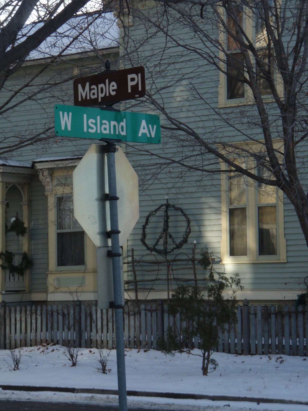
 Which brings us to the street where we began this tour, Maple Place: a left turn at this sign brings me along a short block back to Nicollet and Maple, the precise point at which we began. And if I turn left at that intersection, I am facing an intra-island bridge which enables passage over the railroad tracks, from the NW side of the island to the SE, in the event a train happens to be passing. This next picture shows what I see as I hump my way over this bridge: away in the distance, the distinctive signs for Gold Medal Flour (left) and North Star Blankets (right). These signs are illuminated at night, the Gold Medal Flour sign blinking its three words on in sequence.
 When I reached the center of this bridge, I looked off to my right, to downtown Minneapolis, and noticed that the sign for the new home of the Minnesota Twins (Target Field) is visible from the back. It occurs to me how much of Minneapolis' history and cultural character is reflected in signs visible both on and from Nicollet Island, and I realize how fortunate I am to have the chance to live here and experience it all firsthand. I may not be able to afford an apartment in the heart of Manhattan--but this, here and now, I can do.
 Target Field is located in the Warehouse District west of downtown Minneapolis. The Twins moved to Target Field for the 2010 Major League Baseball season after 28 seasons at the Hubert H. Humphrey Metrodome. The 2010 season was the first since 1936 in which the franchise (then known as the Washington Senators) did not share their home stadium with an NFL team. The first baseball game at the ballpark took place on March 27, 2010, with a college baseball game between the University of Minnesota and Louisiana Tech. The Twins played two preseason games against the St. Louis Cardinals on April 2 and 3, and their inaugural regular season game was played on April 12, 2010 against the Boston Red Sox.
 As I reach the other side, I snap a picture of this plaque identifying the bridge only with a number, as if it were a prisoner: 27695. Evidently, the bridge was completed in 1996, two years before I moved to Minneapolis. The date on the plaque now causes me to view the bridge as though it were not a prisoner, but a corpse resting beneath a headstone. Maybe someday I too will have a plaque: D.E. Sievers, 1960-
But until that day, I will live as much as I can. Coming off this side of the bridge, I find myself on Grove Street--the street that was reduced by more than 50% of its length to make way for the athletic field. From where I stand, I can easily throw a stone the entire length of Grove Street so that it lands in the river. On the one hand of this street stand the historic Grove Street Flats, and on the other, the back of De La Salle High School. If I head toward the river, I will wind up at the intersection of Grove St. and W. Island Ave. But we have been there before, and Sign Day, Part Tveir has now come to an end. Though much of this post may have been on the dullish side, I enjoyed getting to know my island better through its signs. After all, we get to know other people better by studying their signs, do we not? And doctors diagnose our ills by examining our signs. However, some signs can be misleading--a good thing to remember as we attempt to evaluate people, places and things according to the signs they present.
Life flows on, in and around us--leaving its history behind--for where there is life there will always be history, and where there is history you are almost certain to find a sign.
D.E.S.
 This is the Pillsbury's Best Flour sign that graces the old flour mill, on St. Anthony Main, right across the street from where Pillsbury's data center once stood, where yours truly once worked. So technically, the sign is not ON Nicollet Island, but clearly visible from many points on the island. Not a great picture due to the haze, and also one word is blocked, not to mention the picture's failure to reflect the sign's bright red color. But from a historical perspective, I couldn't very well omit this one from Sign Day. And yes, that is the eyesore of a condo apartment building on the left side which I have castigated in previous posts.
 Here I am at the junction of where the Merriam Street Bridge connects to the island, which is most people's main point of entry, hence the informational sign. The sign, which is kiosklike, provides some historical lore about the island, as well as a map and some postings of current (or not so current) local events. Also welcoming visitors to the island, directly across the street from this sign, is the Nicollet Island Inn, a charming little bed and breakfast. Well, maybe not as charming as all that, but it's a nice place with fairly good food (yes, I've slept and eaten there--no complaints)--popular with the romantically-inclined and as a lunch/brunch spot for business meetings.
 Here is one of the Nicollet Island Inn's signs (there are two)--looking at which now, I notice for the first time the announcement of Music Saturday Night in the lounge--well, what have I been missing? I guess I'll have to investigate on one of these Saturday nights when my social calendar is open--keep an eye out for my review. Since having moved to the island, I haven't entered the portals of this venerable institution, possibly because it always seems a bit too venerable for the likes of me. The clientele espied through the windows have appeared, on the whole, of a decidedly sedate and ... mature character. I've never been described as sedate, and while I may have been called a character, the word has yet to be qualified by the word mature.
 While technically, in my view, this one qualifies more as a plaque than a sign, I felt obligated to include it, since it crowns the primary portal to Nicollet Island. I am less impressed by the name of The King Iron Bridge Co. (of Cleveland O.) than by the attractive fleur de lys ironwork ornamenting the overhead crossbar. The bridge, for the math averse, is now 125 years old.
 This next signpost heralds the intersection of Merriam and Power Streets, which I found interesting because the so-called Power Street is not actually a street but the parking lot for the Nicollet Island Pavilion building, which itself is heralded on the lower sign along with its exact address (40 Power St.). The pavilion was built in 1893 as the William Brothers Boiler Works. Nearby was a large Island Power building, which was razed in 1937. It housed a variety of shops driven by a cable connected to a water-powered wheel near Hennepin Island. Hence, the origins of Power Street. But perhaps you'd like a little more detail on the modern day settlement of Nicollet Island, which led to the development that gave Power Street its name:
There are accounts of Indian (Native American, that is) maple sugar camps on the island in the early 19th century. Franklin Steele claimed the island when the east side was opened to white settlement in 1838.
 Franklin Steele (1813 – September 9, 1880) was an early and significant settler of Minneapolis, Minnesota in the United States. Born in Chester County, Pennsylvania of Scottish descent, Steele worked in the Lancaster post-office as a young man, where he once met James Buchanan. With encouragement from his future brother-in-law Henry Hastings Sibley, Steele saw opportunities in the western frontier and traveled to Fort Snelling (Minnesota) where he became a storekeeper at the fort. At that time, the land on both sides of the Mississippi River at St. Anthony Falls was controlled by the U.S. Government as part of the Fort Snelling Reservation. However by 1837 over 150 squatters had staked unofficial claims on fort property. In 1838, the fort commander, Joseph Plympton convinced the government to release the east bank of the river for settlement, hoping to stake a personal claim on the valuable land closest to the Falls. But Steele surreptitiously staked the first claim on the choicest land before sunrise on the first day of legal settlement. He claimed a half-mile of east-bank riverfront, controlling half of the water power of St. Anthony Falls--and including Nicollet Island.
In 1865, William Eastman and John Merriam (namesake of Merriam St. and its bridge) bought Nicollet Island and offered to sell it to the city for a park. When the park proposal was turned down, Eastman and Merriam decided to develop the southern part of the island as an industrial center. In 1869, an attempt to bring waterpower to Nicollet Island failed disasterously when the tailrace tunnel under the river collapsed at the southern tip of the island, nearly destroying the Falls of St. Anthony. The tunnel break was eventually plugged, but no further attempts were made to bring waterpower directly to Nicollet Island.
In 1879, Eastman succeeded in bringing power to Nicollet Island by stringing a long, overhead cable to the island from the east channel dam, through an interchannel tower. It powered various industries housed in the Island Power Building, as well as several nearby factories. It would appear that Power Street received its name around this time, and as a result of this achievement.
Thus ends our history lesson of the day.
 We now resume our tour of signs as we head up E. Island Ave, along the island's eastern shore. As you can see, the day is beginning to brighten up a bit, with sunshine and blue skies coming into the picture, so to speak. In the background of this shot, you can see the eastward-bound off ramp of the Hennepin Bridge, under which I will be passing in just a moment. By the way, when you cross the Merrian St. bridge to the St. Anthony Main side, there is a lovely restaurant called The Wilde Roast Cafe--Oscar Wilde themed and a cozy place to cuddle up on a couch or armchair with coffee and a book (or laptop). A great place to stop for breakfast or brunch during a visit to the Twin Cities.
 If you do visit this area, you'll want to take note of this sign--and take it seriously. Are you familiar with the modern-day implement of torture--reserved for illegal parkers--known as the boot? I have firsthand experience, having been introduced to the boot during my early days in Minneapolis after parking my car illegally near the U. of M. (in the days when I worked on St. Anthony Main, in fact). They fasten a large steel object to one of your car's tires, effectively preventing you from operating your vehicle. You then have to pay a ransom before they will remove the boot. This is not a fun way to while away an afternoon--trust me. I think my ransom was $85.
 Here is the next intersection I come to--E. Island Ave. and De La Salle Dr. And yes, that is De La Salle High School in the background. If I were in a car and turned onto De La Salle Drive, it would take me onto the Hennepin Ave. Bridge--so the street is effectively an on/off ramp to/from the bridge. Seems to me that De La Salle Dr. should be the street running in front of the high school, but in fact that street is Eastman Drive, as you may recall from Part One of our tour, when we were on the west side of the island. And yet, the school's offical address is One De La Salle Drive, even though the school is not fronted by the street of that name. Go figure. You will appreciate the eponymous basis for Eastman Dr. if you were paying attention during our history lesson.
  This Overflow Parking sign, is located in a dirt lot opposite the high school's football field. I have observed, even way back in the days when I worked in the area, that people--at all hours of the day and night--will park in this lot and sit here in their cars. God only knows what they're thinking or doing there, but my observations suggest that these people are not associated with the high school. I guess certain people just know that this is a place where they can park with impunity and sit unobserved for as long as they like, with only the sheer bank of the river behind them. But I've got news for them--they are not as inconspicuous as they may think.
 Although according to this plaque, Grove Street may once have connected the east and west sides of the island, it certainly no longer does. Instead, there is a football field between E. Island Ave. and Grove St. The plaque seems oddly misplaced, for the pedestrian reading its inscription would have a hard time descrying Grove St. anywhere in the immediate area. To reach Grove St., you would have to cross the football field. The only byway connecting east and west in this section of the island, aside from Eastman Dr. in front of the school, consists of the railroad tracks, along which most pedestrians do not travel. I can only assume that perhaps this plaque was placed here before the football field was built, which I understand was relatively recently.
OK -- thanks to Wikipedia, some answers to this riddle and another minor history lesson:
The school had sought to build a 750-seat football field and track, and in March of 2006 permission was granted by the city council. Work on the stadium was completed, despite objections from the Minneapolis Heritage Preservation Commission and Friends of the Mississippi River, who sought to preserve a 140-year old street [aha - the truncation of most of the original Grove Street!] that was removed to build the field. DeLaSalle Athletic Field has been open and in use as of September 2009.
 I will spare you a repeat of the railroad crossing signs, which would merely be a duplication of the signs we visited on the west side of the island. However, I will share this one, encountered just after crossing the tracks, planted in the crotch of the crossroads where one must decide between the upper ground (continuing on E. Island Ave. until it curves around and becomes W. Island Ave.) and the lower ground, a dirt path that leads to the Tweedy-Loweth Bridge (described in previous posts and featured at the top of this blog's Home Page). Despite the sign, I have seen tire tracks in the snow along this dirt path, which, however, probably belonged to city vehicles such as the crew that was clearing shoreline timber in a previous post.
 Which brings us to the street where we began this tour, Maple Place: a left turn at this sign brings me along a short block back to Nicollet and Maple, the precise point at which we began. And if I turn left at that intersection, I am facing an intra-island bridge which enables passage over the railroad tracks, from the NW side of the island to the SE, in the event a train happens to be passing. This next picture shows what I see as I hump my way over this bridge: away in the distance, the distinctive signs for Gold Medal Flour (left) and North Star Blankets (right). These signs are illuminated at night, the Gold Medal Flour sign blinking its three words on in sequence.
 When I reached the center of this bridge, I looked off to my right, to downtown Minneapolis, and noticed that the sign for the new home of the Minnesota Twins (Target Field) is visible from the back. It occurs to me how much of Minneapolis' history and cultural character is reflected in signs visible both on and from Nicollet Island, and I realize how fortunate I am to have the chance to live here and experience it all firsthand. I may not be able to afford an apartment in the heart of Manhattan--but this, here and now, I can do.
 Target Field is located in the Warehouse District west of downtown Minneapolis. The Twins moved to Target Field for the 2010 Major League Baseball season after 28 seasons at the Hubert H. Humphrey Metrodome. The 2010 season was the first since 1936 in which the franchise (then known as the Washington Senators) did not share their home stadium with an NFL team. The first baseball game at the ballpark took place on March 27, 2010, with a college baseball game between the University of Minnesota and Louisiana Tech. The Twins played two preseason games against the St. Louis Cardinals on April 2 and 3, and their inaugural regular season game was played on April 12, 2010 against the Boston Red Sox.
 As I reach the other side, I snap a picture of this plaque identifying the bridge only with a number, as if it were a prisoner: 27695. Evidently, the bridge was completed in 1996, two years before I moved to Minneapolis. The date on the plaque now causes me to view the bridge as though it were not a prisoner, but a corpse resting beneath a headstone. Maybe someday I too will have a plaque: D.E. Sievers, 1960-
But until that day, I will live as much as I can. Coming off this side of the bridge, I find myself on Grove Street--the street that was reduced by more than 50% of its length to make way for the athletic field. From where I stand, I can easily throw a stone the entire length of Grove Street so that it lands in the river. On the one hand of this street stand the historic Grove Street Flats, and on the other, the back of De La Salle High School. If I head toward the river, I will wind up at the intersection of Grove St. and W. Island Ave. But we have been there before, and Sign Day, Part Tveir has now come to an end. Though much of this post may have been on the dullish side, I enjoyed getting to know my island better through its signs. After all, we get to know other people better by studying their signs, do we not? And doctors diagnose our ills by examining our signs. However, some signs can be misleading--a good thing to remember as we attempt to evaluate people, places and things according to the signs they present.
Life flows on, in and around us--leaving its history behind--for where there is life there will always be history, and where there is history you are almost certain to find a sign.
D.E.S.